Metadata 13
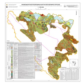 Engineering-geological map of the Republic of Srpska 1:300 000 is the first clear map of Srpska that shows engineering-geological structure of the terrain. Engineering-geological map of the Republic of Srpska 1:300 000 and the Interpreter, contain a general presentation of all elements of the geological environment and provide quick information on all important issues related to engineering geological structure of the terrain, the character of the rocks and soils, condition and properties of rock masses in...

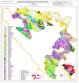 The Formational Geological Map of the Republic of Srpska 1:300 000, represent a thematic clear geological map, on which the basis mapping unit is formation and which also representing one of the fundamental geological concepts. The Geological Maps of the Republika of Srpska 1: 300 000 and the accompanying interpreter, maps and interpreters of the OGK SFRY 1: 100 000 which covers the territory of the Republic of Srpska as well as the latest results printed in publications or presented at conferences and con...
 The Geological map of the Republic of Srpska (1:300 000) is the first clear map of Srpska that shows geological structure and the history of the terrain creation from the Paleozoic to the Quaternary, covering the period of more than 600 million years. Knowledge of geological structures is particularly important for every state, because it conditions the richness or poverty in terms of mineral resources. A type and kind of rocks are prerequisites for the creation of drinking water reserves, and bedrocks, to...
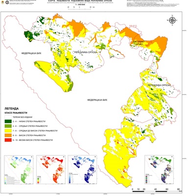 Assessment of the potential threat of groundwater from pollution (i.e. natural vulnerability) is a necessary base for any type of planning and management of groundwater resources. The ultimate goal of the vulnerability map is the subdivision of an area into several units showing the differential degree of vulnerability. Isolated areas or vulnerability classes are presented in different colors or hatches, very easy to understand for the entire professional public, not just geological (which is very importan...
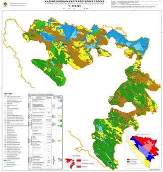 The Hydrogeological Map of the Republic of Srpska 1:300.000 in its widest sense is a graphical representation of hydrogeological characteristics of the territory of the Republic of Srpska. Its preparation is based on the synthesis of the existing geological structure data, hydrogeological categorization of the rocks and hydrogeological regionalization of the Republic of Srpska. The Clear Hydrogeological Map is prepared using modern sofware – programs and tools of the GIS, which enable the creation of hydro...
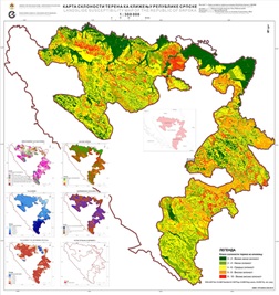 Landslide Susceptibility Map of the Republic of Srpska is prepared using the expert AHP methodology and it shows a proposal of the terrain ranking in terms of spatial expectance of landslides in some areas. These maps are very suitable clear maps, comprehensible to experts from different fields, primarily spatial planning, urbanization etc. The preparation of this map, using the modern GIS tools, is a very useful way of prevention and the prerequisite for rational and meaningful struggle against landslides...
 Metallogenic map of the Republic of Srpska represents the basis for assesing the ore potential and prospect of particular territory in order to increase the degree of economy and effectiveness of future geological researches metallic and non-metallic mineral raw materials and solid fossil fuels of the Republic of Srpska. The basis for preparation of this Metallogenic Map is the Formational Geological Map of the same scale which was created on the basis of the Basic Geological Map of SFRY 1:100 000, the Geo...
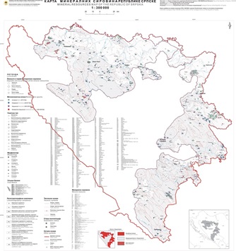 The preparation of this map was preceded by the preparation of the Mineral Resources Cadastre of the Republic of Srpska. The process of creating the cadastre itself is an extensive multi-year work that includes a field work as well as electronic data processing. The data from the cadaster are ploted on the previously prepared Geological map and the result of this process is the Mineral Resources map of the Republic of Srpska.
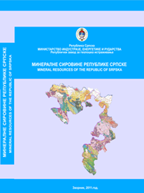 This Monograph has been written with the aim of presenting, the first of all, the mineral resources of the Republic of Srpska, both proven and potential, which should be additionally explored and their importance defined. The Monograph "Mineral Resources of the Republic of Srpska" covers and presents all the mineral resources - ore deposits and significant occurrences - known to date in the territory of the Republic of Srpska. For each mineral resource, the geographical location, level of exploration, chro...
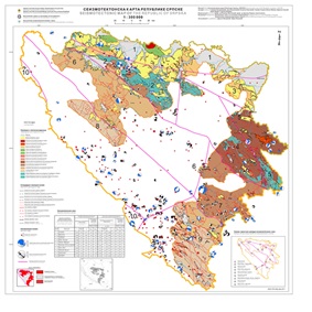 The Seismotectonic Map of the Republic of Srpska 1:300 000 represents an integration of geological, tectonic, seismotectonic and geophysical data on possible earthquake sources. The map is a compilation of all available data and the results of the previous basic and regional geological, seismological and geophysical research and explorations in the teritory of the Republic of Srpska, Bosnia and Herzegovina and the region. The knowledge of seismotectonic characteristics of the region enables the characteriz...