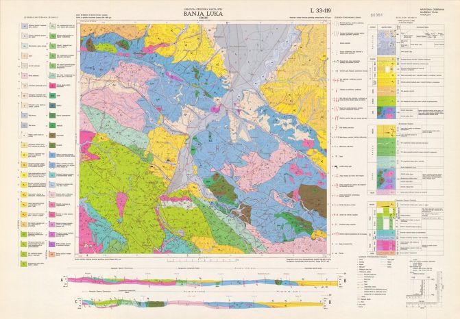
The Basic Geological Map (BGM - SFRY, 1:100 000)


The Basic Geological Maps of the SFRY depict the geological setting and the evolutionary history of the terrain from the Paleozoic to the Quaternary, spanning a time interval of over 600 million years. These maps also delineate the key tectonic structures that influenced the regional geological evolution. Furthermore, the maps comprise data on mineral resource occurrences, fossil localities, and other significant geological phenomena. Through these systematic investigations, a vast amount of factographic data was compiled, enabling the study of the structural framework of the primary geotectonic units, as well as a significant refinement of the vertical boundaries within the chronostratigraphic column. The discovery of formations originating from the earliest stages of the Earth's crust evolution, combined with new data on the detailed subdivision of Mesozoic, Tertiary, and Quaternary sediments, has provided the basis for addressing numerous practical challenges within the territory of Republika Srpska. Today, these maps represent a fundamental source of information for geological exploration, spatial planning, and natural resource exploitation. The territory of Republika Srpska is covered by 43 sheets of the SFRY Basic Geological Map at a scale of 1:100,000.
скуп података
https://data.rzzgi.bh/id/ОGKSFRJ100
Енглески, Српски
Геонаучне информације
GEMET - INSPIRE themes, version 1.0:
 Spatial scope:
GeoERA Keyword Thesaurus:
European Geoscience Registry - Projects:
Spatial scope:
GeoERA Keyword Thesaurus:
European Geoscience Registry - Projects:
Слободне:
geological maps
15.672,
42.528,
19.682,
45.336
публикација: 1967
1958
-
1990
вектор
The Basic Geological Map was compiled with the objective of documenting and depicting the regional geological setting, thereby serving as an essential technical baseline for various applications. The map provides key insights into the lithological, stratigraphic, and tectonic characteristics of the area, thus supplying indispensable data for land-use planning, natural resource exploration, geohazard assessment, and environmental protection, as well as for professional, scientific, and educational activities. Data concerning the delineated geotectonic units, sedimentary evolution, and the distribution of mineral resources within the structural framework of the terrain provide an irreplaceable foundation for executing diverse engineering projects in the fields of mining, civil engineering, water management, and forestry. A particular value of this map lies in its capacity for predicting and identifying deeper subsurface geological features or mineralisations that are frequently obscured at the Earth's surface. Consequently, the Basic Geological Map constitutes a document of paramount importance for planning future detailed geological exploration and all other anthropogenic activities within the lithosphere.
Geological Survey of the Republic of Srpska
Cvjetko Sandić
Вука Караџића 148 Б,
Зворник,
75400,
Bosnia and Herzegovina
tel: +38765349219
email:
c.sandic@geozavodrs.com
Улога: чувар
Квалитет података
The territory of the Republic of Srpska is covered by 43 sheets of the SFRY Basic Geological Map at a scale of 1:100,000, which were compiled within the framework of the former state during the second half of the 20th century. A large number of experts participated in this long-term process; specifically, for the production of the sheets covering the territory of the Republic of Srpska, field mapping was conducted by approximately 80 geologists and geological technicians over more than two decades of continuous work. The majority of the human resources consisted of experts from the Geoinstitut Sarajevo, one of whose legal successors is the present-day Geological Survey of the Republic of Srpska. During the compilation of the maps, all significant published papers and studies from the preceding period were utilized, and as a primary outcome, a large number of entirely new occurrences and deposits of various mineral resources were discovered. The work on producing different types of geological maps is to be continued in the upcoming planning period through this Long-Term Program, thereby ensuring direct continuity with the successful endeavors achieved thus far.
Еквивалентна размјера:
1:
100000
Ограничења
Access to and use of data shall be granted in accordance with the applicable legislation, regulations, and official practices of the Geological Survey of the Republic of Srpska.
Access to and use of data shall be granted in accordance with the applicable legislation, regulations, and official practices of the Geological Survey of the Republic of Srpska.
Метаподаци о метаподацима
6a2a5953-081c-414a-a5de-29edb0a010e92
Geological Survey of the Republic of Srpska
Drazan Tokanović
Вука Караџића 148 Б,
Зворник,
75400,
Bosnia and Herzegovina
tel: +38766425072
email:
d.tokanovic@geozavodrs.com
Улога: контакт тачка
2026-06-11