Seismotectonic Map of the Republic of Srpska 1:300 000


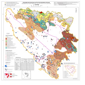
The Seismotectonic Map of the Republic of Srpska 1:300 000 represents an integration of geological, tectonic, seismotectonic and geophysical data on possible earthquake sources. The map is a compilation of all available data and the results of the previous basic and regional geological, seismological and geophysical research and explorations in the teritory of the Republic of Srpska, Bosnia and Herzegovina and the region. The knowledge of seismotectonic characteristics of the region enables the characterization of seismic sources and thus the preparation of a reliable seismic hazard map - a seismological map. The Seismotectonic Map is prepared using the GIS software package. Druing the preparation, the data basis, which is a component of the Geological Information System of the Republic of Srpska, had been created. The Earthquakes' Epicentre Map and the Surface Rupture Map are prepared as the components of the Seismotectonic Map.
скуп података
https://data.rzzgi.bh/id/STKRS300
Енглески, Српски
Геонаучне информације
GEMET - INSPIRE themes, version 1.0:
 Spatial scope:
GeoERA Keyword Thesaurus:
European Geoscience Registry - Projects:
Spatial scope:
GeoERA Keyword Thesaurus:
European Geoscience Registry - Projects:
Слободне:
seismotectonics
16.194,
42.539,
19.666,
45.293
публикација: 2017
2014
-
2017
вектор
Long-Term Program for Development of Basic Geological Explorations of the Republic of Srpska
Geological Survey of the Republic of Srpska
Vladimir Jovičić
Вука Караџића 148 Б,
Зворник,
75400,
Bosnia and Herzegovina
tel: +381649653592
email:
v.jovicic@geozavodrs.com
Улога: чувар
Квалитет података
Geological Survey of the Republic of Srpska and the Republic Hydrometeorological Institute of the Republika of Srpska, recognizing the importance of producing a Seismotectonic Map of the Republic of Srpska and the necessity of a multidisciplinary approach to its creation, jointly implemented the Map Development Project. The key reason for creating the map is the fact that without understanding the seismotectonic characteristics of the region, it is not possible to characterize seismic sources, and thus the creation of a reliable seismic hazard map - a seismological map. The observed problem of the lack of basic backgrounds for map creation, earthquake catalogs, tectonic backgrounds, and maps of regional fault systems, was overcome by their creation during the Project. The Project included the application of modern scientific and professional interpretations, the formation of an up-to-date digital database of analyzed and interpreted data. The goal of creating this map is to characterize seismic energy sources using modern methods, defining the spatial position of active faults and their kinematics, the geometry of seismotectonic zones, as well as the repeatability and maximum expected earthquake magnitude by zones, with the results graphically represented on the Seismotectonic Map of the Republic of Srpska.
Еквивалентна размјера:
1:
300000
Ограничења
Метаподаци о метаподацима
66167090-8280-45bd-937e-3a540a010855
Geological Survey of the Republic of Srpska
Drazan Tokanović
Вука Караџића 148 Б,
Зворник,
75400,
Bosnia and Herzegovina
tel: +38766425072
email:
d.tokanovic@geozavodrs.com
Улога: контакт тачка
2026-02-26